
Cape Cod Guide to Beaches
Cape Cod Guide brings you the best information on Cape Cod beaches. Cape Cod, Martha's Vineyard, and Nantucket are all surrounded by beautiful scenic beaches. There are beaches on the bay and ocean sides of the islands, salt ponds, freshwater and kettle ponds. Bayside beaches are typically much calmer than oceanside, making them perfect destinations for families with children. Come explore the amazing beaches of the Cape and Islands!
Information on this page has been updated for the summer of 2017. Did we miss your favorite Cape Cod Beach? If so, please drop us an email.
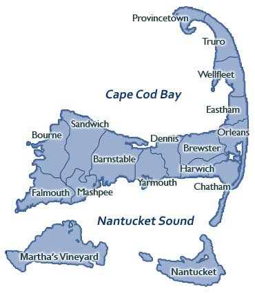
Cape Cod Map
Click on a Town or Island on the Cape Cod beaches map for corresponding Beaches & Ponds:
PUBLIC BEACHES
Craigville Beach: located off Craigville Beach Road on Nantucket Sound. It's one of the Cape's most popular beaches, and has restrooms, concessions, and showers. Google Map to Craigville Beach.
Hathaway's Pond: small freshwater pond located off Phinney's Lane in Hyannis.
Kalmus Park Beach: located on the Lewis Bay at the end of Ocean Street in Hyannis, and has restrooms and concessions. Kalmus is a one of the best locations for windsurfing on Cape Cod. Google Map to Kalmus Park Beach.
Sandy Neck Beach: located on the Cape's Bay side in West Barnstable, this is the Upper Cape's longest beach. Large dunes and a six-mile sand spit may be found here, making it a great four wheeling destination. Sandy Neck offers showers and a snack bar. Google Map to Sandy Neck Beach.
Sea Street Beach: at the end of Sea Street in Hyannis. Google Map to Sea Street Beach.
Veterans Park Beach: behind the Kennedy Memorial on Ocean Street, Hyannis. Google Map to Veterans Park Beach.
RESIDENT BEACHES
Covell Beach: on Cragville Beach Road in Centerville. Google Map to Covell Beach.
Dowses Beach: on East Bay Road in Osterville. Google Map to Dowses Beach.
Eugenia Fortes (East) Beach: on Iyanough Avenue in Hyannisport.
Hamblins Pond: Route 149 in Marstons Mills. Google Map to Hamblins Pond.
Joshua's Pond: Tower Hill Road in Osterville. Google Map to Joshua's Pond.
Loop Beach: on Ocean View Avenue in Cotuit, this beach has restrooms and a bathhouse. Google Map to Loop Beach.
Lovell's Pond: on Newtown Road in Marstons Mills. Google Map to Lovell's Pond.
Millway Beach: on Millway in Barnstable
Wequaquet Lake: off of Shoot Flying Hill Road in Centerville
BOURNE
Resident and Non-Resident Beach stickers can be purchased Monday through Friday 8:30am - 4:30pm at the Department of Natural Resources office at Bourne Town Hall, located at 24 Perry Ave in Buzzards Bay.
For more information on Bourne beach stickers, see the Town of Bourne Beaches, Boat Ramps & Parking information online or call 508.759.0621. Barlows Landing: Off of Route 28 in Pocasset. Google Map to Barlows Landing.
Electric Avenue: Off Electric Avenue in Buzzards Bay.
Hen Cove Harbor: Off of Shore Road and Circuit Avenue in Pocasset
Monument Beach: Overlooks the Cape Cod Canal, located off Route 28 in Bourne. Monument has a snack bar and bathroom facilities, and is also a popular wind surfing location. Google Map to Monument Beach.
Queen Sewell Pond: Off Puritan Road in Buzzards Bay. Google Map to Queen Sewell Pond.
Sagamore Beach: Off of Scusset Beach Road in Sagamore. Google Map to Sagamore Beach.
Scusset Neck: Off of Scusset Beach Road in Bourne, this is a popular recreation area with its campground. There are showers, restrooms, and a picnic area on site. Google Map to Scusset Neck.
Squeteague Harbor: Ocean side beach off of Scraggy Neck and Squeteague Roads in Cataumet.
Picture Lake: Off of Country Road in Pocasset
BREWSTER
Resident and Non-Resident Beach stickers are sold seven days a week from 9am - 3pm at the Brewster Visitor Center in the Brewster Town Hall Offices, 2198 Main Street (Route 6A).
The sticker office is open from June through August. Valid Brewster Beach Stickers are required at Brewster beaches from 9am - 4pm daily through the summer. Brewster's Beaches are located along the Cape Cod Bay where the
waters are calm, and the low tides with water receeding make them ideal for families with children. Click here for a Map of Brewster Beaches and Ponds, and for more information call 508.896.3500. 
Breakwater Beach: A bayside beach off Breakwater Road, off 6A; near the Brewster General Store. This beach is a popular destination for families.
Crosby Landing Beach (Crosby Beach): A bayside beach on Crosby Landing Road, off 6A; about 1.5 miles before the Orleans town line on Route 6A
Ellis Landing Beach: A bayside beach on Ellis Landing Road, off 6A; about 2 miles before the Orleans town line on Route 6A
Linnell Landing Beach: A bayside beach on Linnell Landing Road, off 6A; about 1.75 miles before the Orleans town line
Paine's Creek Beach: A bayside beach on Paine's Creek Road; 1.5 miles west past the intersection of Route 137 and 6A
Point of Rocks Beach: A bayside beach off Point of Rocks Road, off Route 6A; 1 mile east of the intersection of 6A and Route 124
Mant's Landing: A bayside beach 1 mile off Lower Road, which intersects with Route 6A
Nickerson State Park: Nickerson Park off of 6A in Brewster offers beautiful fresh water ponds for swimming and kayaking. Google Map to Nickerson State Park.
Saint's Landing:A bayside beach 1 mile off Lower Road, which intersects with Route 6A
Long Pond: Off of Mammon Drive in Brewster
Upper Mill Pond: Off of Run Hill Road in Brewster
Cockle Cove Beach: On the waters of Nantucket Sound, off Route 28 at the end of Cockle Cove Road. This beach is a favorite among families, with its soft sand and calm waters. Restrooms are available. Google Map to Cockle Cove Beach.
Forest Beach: At the end of Forest Street, south of Route 28. Google Map to Forest Beach.
Goose Pond: Kettlehole pond off of Queen Anne Road. Google Map to Goose Pond.
Hardings Beach: Off Harding's Beach Road; off of Route 28 and Barn Hill Road. This beach is also popular among families, and has restrooms and a snack bar.
Lighthouse Beach: Ocean side beach off of Shore Road.
North Beach: Ocean beach, only accessible via 4WD or boat. There are no restrooms or facilities here, and there is often big surf here.
Oyster Pond: Small saltwater pond, perfect for children; off of Stage Harbor Road; requires a sticker. Google Map to Oyster Pond.
Pleasant Bay: Off of Route 28. Google Map to Pleasant Bay.
Ridgevale Beach: A public beach on Nantucket Sound, off Ridgevale Road; off Route 28
School House Pond: Freshwater pond, off of Queen Anne Road; requires sticker. Google Map to School House Pond.
White Pond: Freshwater pond, off of Queen Anne Road. Google Map to White Pond.
Bayview Beach: Off Route 6A, on the bay side
Chapin Memorial Beach: Off Route 6A in Dennis Village, on the bay side; on Dr. Bottero Road. This is a popular 4WD beach, and a good spot for clamming at low tide. Google Map to Chapin Memorial Beach.
Cold Storage Beach: A bayside beach in East Dennis off School Street and Cold Storage Road.
Corporation Beach: Off Route 6A on Corporation Road, on the bay side. This beach is a popular family destination, and has restrooms, concessions and a playground.Google Map to Corporation Beach.
Depot Street Beach: Depot Street off Lower County Road
Glendon Road Beach: Off Route 28, on the Atlantic side; Old Wharf Road off Lower County Road. Google Map to Glendon Road Beach.
Harborview Beach: Off Route 6A, on the bay side; residents only
Haigis Beach: In Dennis Port off of Lower County Road, Off Route 28, on the Atlantic Ocean side. Google Map to Haigis Beach.
Horsefoot Path Beach: Off Route 6A, on the bay side
Howes Beach: Off Route 6A, on the bay side. Google Map to Howes Beach.
Inman Road Beach: Off Route 28, on the Atlantic side; Lower County Road to Inman Road in Dennisport. Google Map to Inman Road Beach.
Mayflower Beach: Off Route 6A, on the bay side. This beach is a popular family destination, with restrooms and concessions available. Google Map to Mayflower Beach.
Sea Street Beach: Off Route 28, on the Atlantic side; in Dennisport. Google Map to Sea Street Beach.
South Village Road Beach: In Dennis Port off of Route 28, on the Atlantic side
West Dennis Beach: In Dennis Port off of Davis Beach Road, this is a mile-long beach with a bathhouse, restrooms, boardwalk, and plenty of parking
Campground Beach: A bayside beach located off Shurtleff Road. Google Map to Campground Beach.
Coast Guard Beach: An oceanside beach maintained by the Cape Cod National Seashore; no parking is available; shuttle service from a large parking lot off Nauset Road. This beach is one of the favorites amongst Cape Cod tourists, and is popular for surfing and swimming. Google Map to Coast Guard Beach.
Cole Road Beach: A bayside beach located off Cole Road, off Herringbrook Road
Cooks Brook Beach: A bayside beach in North Eastham; off Steele Road, off Massasoit Road. Google Map to Cooks Brook Beach.
First Encounter Beach: Located at the end of Samoset Road, off Route 6. Google Map to First Encounter Beach.
Kingsbury Beach: A bayside beach located off Kingsbury Beach Road, off Route 6. Google Map to Kingsbury Beach.
Nauset Light Beach: An oceanside beach maintained by the Cape Cod National Seashore; follow Brackett Road off of Route 6. This beach is idea for surfing and swimming, and has restrooms and showers available. Google Map to Nauset Light Beach.
Sunken Meadow Beach: A bayside beach located off Massasoit Road, off Route 6. Google Map to Sunken Meadow Beach.
Thumpertown Beach: A bayside beach off Thumpertown Road, off Herringbrook Road. Google Map to Thumpertown Beach.
Great Pond: Fresh water pond off of Great Pond Road. Google Map to Great Pond.
Herring Pond: Fresh water pond off of Crosby Village Road. Google Map to Herring Pond.
Wiley Park: Fresh water pond off of Herringbrook Road. Google Map to Wiley Park.
Chapoquoit Beach: Bayside beach off Chapoquoit Road in West Falmouth. This beach is referred to as "Hog Island" by locals. There are restrooms and a concession truck in the summer.
Megansett Beach: Bayside beach off County Road in West Falmouth
Old Silver Beach: Bayside beach off Quaker Road in North Falmouth. This beach is a popular family destination, and the waters are typically quite warm in the summer. There are restrooms, concessions and a bathhouse. Google Map to Old Silver Beach.
Wood Neck Beach: Bayside beach off Palmer Avenue and Sippewissett Road. Google Map to Wood Neck Beach.
Bristol Beach: Sound beach off of Menauhant Road
Falmouth Heights Beach: Sound beach, take Falmouth Heights Road to Grand Avenue. Google Map to Falmouth Heights Beach.
Menauhant Beach: Sound beach off Menauhant Road in East Falmouth. Google Map to Menauhant Beach.
Stoney Beach: Sound beach north of Woods Hole Drive, in Woods Hole
Surf Drive Beach: Sound beach located on Surf Drive, this beach is a popular destination for families. There are public restrooms, concessions, and showers available. Google Map to Surf Drive Beach.
Bank Street Beach: Located on Nantucket Sound near Harwichport center; at the end of Bank Street. This beach is typically busy in the summer season, and with its warmer waters is a great location for swimming. Google Map to Bank Street Beach.
Bucks Pond Beach: Fresh water beach off of Route 39
Earl Road Beach: Earl Road, off of Lower County Road
Fernandes Bog: Off of Long Pond Drive, between Routes 137 and 124
Long Pond: A large freshwater pond located off of Routes 124 and 137. Google Map to Long Pond.
Pleasant Bay: Off of 28 on Pleasant Road in West Harwich; limited parking available
Red River Beach: One of Harwich's larger beaches, off Route 28. This beach is also a great location for swimming, and has restrooms available. Google Map to Red River Beach.
Sand Pond: Near town center, on Great Western Road. Google Map to Sand Pond.
South Cape Beach: Located on Great Oak Road; great fishing and a concession stand, parking, and restrooms. Google Map to South Cape Beach.
Attaquin Park (Mashpee/Wakeby Lake): Freshwater lake located in Mashpee off Route 130
Johns Pond: Freshwater pond located off Route 151 and Currier Road. Google Map to Johns Pond.
PUBLIC BEACHES
Gay Head Public Beach (Moshup Beach): Surf beach in Aquinnah, off of Moshup Trail; paid parking in summer only. Google Map to Gay Head Public Beach.
East Beach: Located on Chappiquiddick Island; fee for non-members. Google Map to East Beach.
Eastville Beach: Located at the bridge between Oak Bluffs and Vineyard Haven. Google Map to Eastville Beach.
Fuller Street Beach: Located at the end of Fuller Street in Edgartown. It has a great view of the harbor traffic. Google Map to Fuller Street Beach.
Joseph Sylvia State Beach: Located between Oak Bluffs and Edgartown on the Nantucket Sound. It is accessible by Beach Road and the bike path. It has small waves and shallow water, perfect for the kids! The Edgartown end of the beach is known as Bend-in-the-Road Beach. Google Map to Joseph Sylvia State Beach.
Lake Tashmoo Beach (Herring Creek Beach): At the end of Herring Creek Road in Edgartown. Google Map to Lake Tashmoo Beach.
Lighthouse Beach: A harbor beach at Starbuck's Neck in Edgartown. Google Map to Lighthouse Beach.
Long Point Beach: Located at Long Point Wildlife Refuge, off of Waldron's Bottom Road. A nice pond adjacent to the Atlantic Ocean, great for kids of all ages! Google Map to Long Point Beach.
Menemsha Beach: Next to Menemsha Harbor. Google Map to Menemsha Beach.
Norton Point Beach: On the south shore of Edgartown at the end of Katama Road. Google Map to Norton Point Beach.
Oak Bluffs Town Beach: Located off Lake Avenue on the Nantucket Sound side of Oaks Bluff. Google Map to Oak Bluffs Town Beach.
Owen Park Beach: Harbor beach located off Main Street in Vineyard Haven; on Vineyard Haven Harbor. Google Map to Owen Park Beach.
Tisbury Town Beach (Owen Little Way Town Beach): Off of Owen Little Way, next to the Yacht Club. Google Map to Tisbury Town Beach.
RESIDENT BEACHES
Head of the Pond Beach: Located in Aquinnah
Lambert's Cove Beach : Located in West Tisbury. Google Map to Lambert's Cove Beach.
Lobsterville Beach: Located in Aquinnah. Google Map to Lobsterville Beach.
Lucy Vincent Beach: Located in Chilmark. Google Map to Lucy Vincent Beach.
Philbin Beach: Located in Aquinnah. Google Map to Philbin Beach.
Squibnocket Beach: Located in Chilmark. Google Map to Squibnocket Beach.
Brant Point Beach: Located on the Nantucket Sound side of the island. Google Map to Brant Point Beach.
Children's Beach: Located on the Nantucket Harbor, ideal beach for children. Google Map to Children's Beach.
Francis Street Beach: Located on the Nantucket Sound side of the island near downtown
Miacomet Beach: Located at the end of Miacomet Road. Google Map to Miacomet Beach.
Cisco Beach: Located at the end of Hummock Pond Road. Google Map to Cisco Beach.
Jetties Beach: Located on the Nantucket Sound side of the island, great for families. Google Map to Jetties Beach.
Dionis Beach: Located on the Nantucket Sound side of the island, good beach for children. Google Map to Dionis Beach.
Madaket Beach: Located on the southwest side of the island in Madaket. Google Map to Madaket Beach.
South Beach: Off Washington Street near downtown Nantucket. Google Map to South Beach.
Surfside Beach: At the end of Surfside Road, good beach for families. Google Map to Surfside Beach.
Siasconset Beach: On the southeast corner of the island in Siasconset; off Low Beach Road. Google Map to Siasconset Beach.
Nauset Beach: Located at the end of Beach Road in East Orleans on the ocean side; restrooms and food available. Google Map to Nauset Beach.
Skaket Beach: A bayside beach off of Skaket Beach Road; a great place to view a sunset. Google Map to Skaket Beach.
Pilgrim Lake: Fresh water beach on Monument Road off of Main Street. Google Map to Pilgrim Lake.
Herring Cove Beach: At the tip of the Cape; a narrow ocean beach with parking almost directly on the beach; maintained by the Cape Cod National Seashore; restrooms and food available. Google Map to Herring Cove Beach.
Race Point Beach: Off Route 6; an ocean beach that is good for surf-fishing. Google Map to Race Point Beach.
Harbor Beach: Runs parallel to Commercial Street, along the bayside; park at MacMillan Wharf
Long Point Beach: At the very tip of the Cape where Long Point Lighthouse signals; access by water shuttle or walk from end of Commercial Street
Hatches Harbor: Off of Herring Cove, access by walking or beach vehicle
East Sandwich Beach: Off Ploughed Neck Road off Route 6A. Google Map to East Sandwich Beach.
Sandwich Town Beach: On Town Neck Road; has a boardwalk over the marsh on the way to the beach. Google Map to Sandwich Town Beach.
Sandy Neck Beach: A large, long bayside beach that extends into Barnstable with a good sized parking area; popular spot for off-road vehicle (ORV) trails. Google Map to Sandy Neck Beach.
Mashpee-Wakeby Pond Beach: Fresh water pond off of Sandwich-Cotuit Road
Ballston Beach: Off of North Pamet Road on the ocean side; also called Pamet Beach. Google Map to Ballston Beach.
Head of The Meadow Beach: Ocean side beach in North Truro; off Head of the Meadow Road Road; fee required. Google Map to Head of the Meadow Beach.
Long Nook Beach: On the ocean side; at the end of Longnook Road off Route 6. Google Map to Long Nook Beach.
High Head: Off Route 6 on the ocean side; at the end of High Head Road; four wheel vehicle access. Google Map to High Head Beach.
Coast Guard Beach: On the ocean side; at the end of Coast Guard Road. Google Map to Coast Guard Beach.
Hopper Beach: Ocean side beach off of Route 6; four wheel vehicle access
Pilgrim Beach: A narrow bayside beach off of Route 6A
Pond Village Beach: A bayside beach off of Route 6A. Google Map to Pond Village Beach.
Corn Hill Beach: A bayside beach on Corn Hill Road; great view of Provincetown; fee required. Google Map to Corn Hill Beach.
Fisher Road Beach: Off Route 6 and Old County Road on the bayside
Great Hollow Beach: A bayside beach off Route 6 on Great Hollow Road. Google Map to Great Hollow Beach.
Ryder Beach: A bayside beach off Route 6; off Prince Valley and Ryder Beach Roads. Google Map to Ryder Beach.
Cahoon Hollow Beach: An ocean side beach at the end of Cahoon Hollow Road, off Route 6. Google Map to Cahoon Hollow Beach.
Lecounts Hollow Beach (Maguires Landing): An ocean side beach 2.5 miles north of the Eastham line; off Lecount Hollow Road. Google Map to Lecounts Hollow Beach.
Marconi Beach: An ocean side beach maintained by the Cape Cod National Seashore; off Route 6 in South Wellfleet. Google Map to Marconi Beach.
Newcomb Hollow Beach: An ocean side beach almost at the Truro line; off Gross Hill Road. Google Map to Newcomb Hollow Beach.
White Crest Beach: An ocean side beach off of Ocean View Drive; up from Lecount Hollow Beach. Google Map to White Crest Beach.
Mayo Beach: A bayside beach on Commercial Street off of Route 6. Google Map to Mayo Beach.
Powers Landing: A bayside beach off of Chequesset Neck Road. Google Map to Powers Landing.
Duck Harbor Beach: A bayside beach off of Duck Harbor Road, off of Chequesset Neck Road. Google Map to Duck Harbor Beach.
Indian Neck Beach: A bayside beach off of Pilgrim Spring Road. Google Map to Indian Neck Beach.
Great Pond: Off of Cahoon Hollow Road off Route 6. Google Map to Great Pond.
Gull Pond: Off of Gull Pond Road off Route 6. Google Map to Gull Pond.
Long Pond: Off of Long Pond Road off Route 6. Google Map to Long Pond.
Bass Hole Beach (Gray's Beach): Overlooking Bass Hole in Yarmouthport; at the end of Center Street; some free parking. Google Map to Bass Hole Beach.
Bass River Beach (Smuggler's Beach): At the end of South Shore Drive, off Old Main; fee required. Google Map to Bass River Beach.
Bay View Beach: Overlooking Nantucket Sound; almost at the Barnstable town line; free parking. Google Map to Bay View Beach.
Colonial Acres Beach: On Bay View Street off of Lewis Bay Road; free parking
Englewood Beach: Located on Berry Avenue; free parking. Google Map to Englewood Beach.
Parkers River Beach: Off of South Shore Drive; fee required. Google Map to Parkers River Beach.
Sea Gull Beach: Off of Sea View Avenue; the largest Yarmouth Beach; fee required. Google Map to Sea Gull Beach.
Sea View Beach: Off Route 28 in West Yarmouth; on South Shore Drive. Google Map to Sea View Beach.
Windmill Beach: On River Street near the Bass River; free parking. Google Map to Windmill Beach.
South Middle Beach: Off of South Shore Drive; residents only